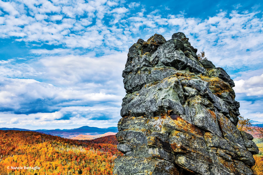
The view from Mount Adams, near Newcomb. Photograph by Tim Rowland
Mount Adams is a dazzling but somewhat difficult hike, with a distance and gain in elevation similar to the High Peak of Cascade, even though its elevation is some five hundred feet less. My gizmo clocked it at 5.3 miles round trip, but then I tend to poke around a bit, so my totals always come in on the high side; the official distance round trip is 4.8 miles.
If Mount Adams were on the northern side of the High Peaks, safe to say it would be crawling with hikers like Ampersand and Hurricane. But it sits to the south, far from the madding crowds and relatively unnoticed. The southern access to the High Peaks is starting to draw a bit more attention, but it’s still just a trickle compared to the waves of hikers at the northern trailheads in Keene Valley. The reasons are threefold: One, there are limited services—hotels, restaurants, nightlife—to the south; two, the trails into the High Peaks are somewhat longer by way of the south; and three, there’s no quick and easy way to get from the lights of Lake Placid to the tiny town of Newcomb, which is the closest thing to a population center to the southern trails.
If you’re staying in Lake Placid, getting to Newcomb will add two and a half hours of drive time to your day. From the Northway at Exit 29 alone, it’s another 20 miles to Newcomb over the Blue Ridge highway, and if you pass five cars the whole way, consider it a traffic jam.
If you can live without disco balls, it’s even worth staying on the south side—there are some charming inns and bed and breakfasts in Newcomb, and it boasts an excellent outfitter, camping, a museum, golf course and two restaurants that can go toe to toe with any in the park.
The trails in the south are far less crowded, the history is more interesting and there is one more perk nobody ever mentions: This far north the sun arcs across the southern skies over the course of the day, which means views of the High Peaks from such northern mountains as Van Hoevenberg and Hurricane can leave you with barbecued eyeballs. From the south, you can get a spectacular view of the peaks with the sun behind you. It seems like a small point, but particularly in the spring and fall the High Peaks from the north appear as silhouettes, while from the south the stony summits pop with saturated color.
The fraught history of this region is forged from the rich veins of iron discovered in 1826. The McIntyre Range (including the High Peaks of Algonquin, Wright and Iroquois) was named for an early investor—first name Archibald—in the mines, and determined little villages sprouted at the headwaters of the Hudson as men—who would ultimately be no match for the mighty mountains—scratched away at the earth seeking fortunes in the wilderness.
David Henderson, an enthusiastic, fiddle-playing Renaissance man who by all accounts was well-loved and did not fit the robber-baron profile, appeared for a time as if he might actually conquer the unconquerable. But his life ended abruptly due to the accidental discharge of a firearm. The tragedy gave rise to the names of Calamity Brook, Calamity Pond, Calamity Mountain and such.
Without Henderson’s energy, the mining industry died out, only to revive during World War II, when the government built a railroad to the site to facilitate extraction of titanium. For about 40 years the mines thrived before dying out once again.
But before they did, they gave rise to one of the more bizarre events in Adirondack history. The company discovered a rich new vein of ore located smack dab beneath the mining town of Tahawus (pronounced t’HAWS). So in 1963 they jacked up the whole town and moved nearly one hundred houses, apartments, churches and stores twelve miles down the road.
But perhaps the area’s most noteworthy historical footnote, given its national import, was Teddy Roosevelt’s urgent ride from Mount Marcy to the North Creek railroad station following the fatal shooting of William McKinley in 1901.
The main access to the High Peaks from the south is at a trailhead that derives its name, the Upper Works, from the old mining days. The town of Newcomb and the Open Space Institute have improved the trailhead, including interpretive signs for buildings in the old mining town of Adirondac near the Upper Works. The buildings of the old ghost town had remained standing into the 21st Century, but were decaying fast and had to be removed. Today, their fireplaces and chimneys remain, along with drawings of what they looked like back in the day.
On your right, a few hundred yards before you get to the Upper Works trailhead, are the ruins of a massive, 170-year-old blast furnace, and beyond that is a parking lot for another trailhead that gets comparatively little use.
A goodly share of the people parking here, bless their hearts, are on their way to Allen Mountain, the most remote of the 46 High Peaks, requiring a twenty-mile round trip march. The other mountain accessible from this trailhead is 3,500-foot Mount Adams which, foot-for-foot, might just have the best view of any mountain in the Adirondacks.
Yet Adams remains an afterthought for a couple of reasons. Most notably, it would have no view were it not for the fire tower at the top, which has only recently been restored. And, as mentioned, getting to the southern peaks access point is a haul, and most people who make the commitment have bigger fish to fry as they slog their way through the 46. Finally, Mount Adams is a pretty brutal hike, or at least it is over the last half mile, where the trail, in old ADK fashion, goes straight up the mountain with nary a switchback in sight.
From the trailhead, the route quickly arrives at the Hudson River, which is crossed by a sketchy suspension footbridge that would be right at home in the Annapurna Region of Nepal. Before crossing, there are signs to the MacNaughton Cottage—named for James MacNaughton, son-in-law of Archibald—which was built in 1834, and is the only surviving building from the days of David Henderson and the old village of Adirondac. The community was abandoned in 1858, but the cottage served as the residence for a couple of caretakers who dutifully watched the forest reclaim the former industrial site. The buildings and surrounding lands were leased to a hunting club in 1877, and it was in the cottage that T.R. was staying after McKinley was shot.
Adirondac had a brief renaissance as quarters for titanium miners around the time of the Second World War, but it didn’t last, and by the 21st century the cottage and other remaining Adirondac buildings were nothing but a sad, although fascinating, ghost town.
When the Open Space Institute purchased the lands in 2003, it made the happy decision to preserve and repurpose the cottage.
All that is to say, if you don’t like the looks of the bridge, you have other options. But soldiering on will reward you with passage through a lovely evergreen forest to the shores of Lake Jimmy, which twenty years ago could be crossed on an assemblage of water-level platforms that left you thinking maybe the swaying old suspension bridge wasn’t so bad after all. The wreckage of this old infrastructure is scattered about the shoreline and can actually be seen from the Mount Adams fire tower—which is not the same as being able to see it from space, but still is kind of strangely intriguing.
Without the bridge, hikers are routed through a soggy mess around the lake’s northern shore, which in itself is an indication of why the bridge was needed in the first place. Mossy, boggy wetlands are pretty and interesting, but you do need to watch your step until the new trail rejoins the old at the far end of the former bridge.
As the trail climbs gently from the lake, it passes the old fire tower observer’s cabin on the left. If you go nosing around the cabin, and we all know that you will, a spot of care is needed to get back on the correct trail, as a couple of other trail-like old logging roads radiate out from the site. The correct trail rises along an old road toward a hump, where at 1.2 miles, hikers to Mount Adams turn left and the fools heading to Allen will continue straight.
Turning left onto the Adams trail starts out peacefully enough, climbing through a hardwood forest and crossing a well-defined old woods road that kind of makes you want to take it just to see where it goes. It’s all very pleasant for another half mile, until the trail loses its innocence with a demanding summit approach that scarcely lets up. The part that will stick in your mind is where the trail ascends aggressively along the base of a vertical rock face with little to offer in the way of security. If you forgot your rock-climbing shoes it’s possible to skirt the obstacle to the right, although that isn’t a lot of fun either. Most people who are descending either crab walk, slide on their tuchus or inch their way down, arms and face pressed up against the cliff—none of which, for grace, will earn you a spot on Dancing with the Stars.
The trail from there continues to climb steeply, although non-life-threateningly, through a big, beautiful forest until the tower appears almost magically out of the evergreens. If the mountain profiles are unfamiliar from the south no matter, because the restored tower has a sundial-like key identifying the dozens of visible peaks. Notable are the Marcy-Colden-Algonquin trinity, along with a dramatic view of Wallface and Skylight, and a novel perspective on the Santanoni range and the southern High Peaks of Redfield, Cliff and, yes, Allen. To the south you can see forever, to Gore and beyond.
Even with lots of time at the top, the hike can be completed in under four hours, leaving time to explore the blast furnace, the MacNaughton Cottage and what’s left of the village of Adirondac. Or if you didn’t check out the observer’s cabin on the way up, do so on the way down—with new appreciation for the ranger’s daily commute to the tower.
If You Go
Distance: 5 miles
Difficulty: Hard
Directions: From Northway Exit 29, travel west on Blue Ridge Road for 17.5 miles. Turn right onto Tahawus Road, which becomes Upper Works Road.
Adapted from Happy Lonesomes: A Guide to 15 Eastern Adirondack Hikes That Are Long on Scenery and Short on Crowds (2022, High Peaks Publishing), by Tim Rowland, available at www.adirondacklifestore.com.